
Route Map
Total Distance – 6.47 miles (10.4 km)
Total Ascent – 1,175 ft (358m)
This blog can also be watched on the Videos page here

We pulled into the market square in Settle on Saturday morning and doubled back on ourselves and headed along High Street and past the Talbot Arms pub. We then joined the narrow and cobbled Victoria Street and started climbing up out of the town centre with the car engine revving higher as we climbed. We took a slight left turn and proceeded along and up Albert Hill. Had we continued straight onto Commercial Street we would have got to what is probably the smallest art gallery in the world, The Gallery on the Green, which is situated in a disused telephone box higher up in the town. We continued rising up out of the town and headed along High Hill Lane which eventually leads to Airton over in Malhamdale, where we pulled over to the side of the road and parked just after the junction with Stockdale Lane along with five other vehicles.
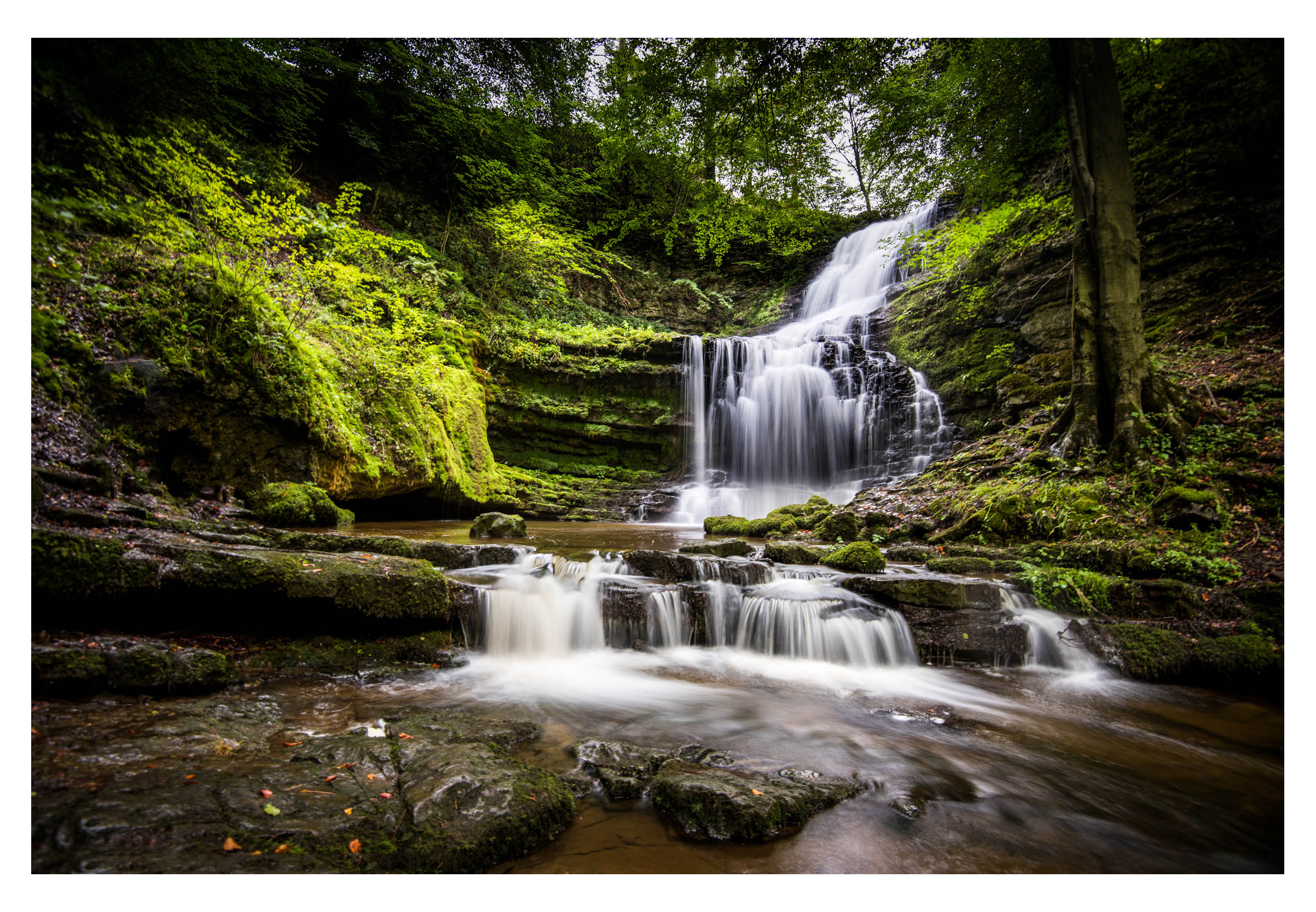
Our first stop was down the road a little to have a look at Scaleber Force, and whilst slightly off the planned circular route was well worth having a look at for the very minor detour it involved. Scaleber force is located in quite a deep limestone gorge and is where Stockdale Beck tumbles down over a series of fractured limestone slabs and into Scaleber Wood. The route down can be a little tricky, and some of the rock was damp and slippery underfoot. It is not one to be done in dazzling white new trainers as a family of five found out when trying to get down there at the time of my visit, much to their distress. Get yer boots on! …and be prepared to get them muddy. There are two paths to the waterfall, both start at the same point but split and one takes you to a sort of halfway point of the falls whilst the other lower path takes you down to the bottom of the falls where they decant into Scaleber Beck. From a photography point of view, the upper falls are the more aesthetically and compositionally pleasing.
After looking around for a short while and taking in the scene we made our way back up from the falls within the wooded gorge and back onto High Hill Lane and returned the way we had come so we could pick up the bridlepath that runs up Stockdale Lane. The lane made for good going underfoot and we were soon rising above the surrounding countryside. As we approached a sharp right-hand turn in the lane, the public footpath continued over the wall and formed a neat green track along the lower flanks ofHigh Hill to our left. We continued ascending this green route until the path levelled and we were greeted with the rocky outline of Warrendale Knotts in the near distance. These are a small outcrop of rocky hills which had the appearance of a stage set taken from “The Land That Time Forgot” – all that was missing was the dinosaurs and Susan Penhaligon. We passed by and around the rear of the unusually named Sugar Loaf Hill and started to drop down to a stepped stone stile over a drystone wall. We climbed the stile, and took the path to our right leading over to Attermire Scar and then turned left to walk under the craggy escarpment.


We climbed up a steep, boulder-strewn path to gain height to the path leading to along the limestone escarpment to our right which contained three caves. The first of these cases was Attermire Cave which is high in the limestone escarpment. Attermire Cave has been explored by antiquarians since the 1870s. It was extensively excavated in 1930 and 1931 and again in the early 1940s. The cave seems to have been used during the Neolithic and early Bronze Age, then abandoned and possibly blocked up until the Romano-British period. Twenty-eight Romano-British brooches of various types were found along with coins, bone items, a possible Roman lead bowl lamp and the dismantled remains of a chariot consisting of the iron wheel tyres, nave hoops and lynchpin. A chariot! The path is a little tricky to navigate to and requires a good head for heights as can be seen from the photograph of the entrance. We didn’t enter this particular cave as it was a bit off our route and I have been in it before, albeit many years ago.

The other visible cave to the left of Attermire Cave is Lookout Cave, which is higher up in the hillside and has possibly obtained its name due to the height and extensive views which it commands, or it could also be named due to the need to be forewarned when stepping out of it as there is a 100ft vertical drop about 8 feet from the entrance – “Lookout!”….

As with Attermire cave, we didn’t visit this one either, but continued along the gravel path at the base of the scar and followed the drystone wall to our left. The wall and path continued onwards in a northerly direction run just beneath the entrance toVictoria Cave. The discovery of Victoria Cave is an epic tale which began one day in the spring of 1837, just before the accession of the young QueenVictoria. Michael Horner and some friends from Settle were out walking with their dogs in the Yorkshire Dales. When one of the hounds ran off ahead and disappeared down a foxhole, as dogs do and Michael decided to follow it. I am unable to decide whether this was an act of bravery as he cared deeply for the dog or sheer stupidity – it’s a fine line between the two and I’m torn as to which it was in this case.
Michael found himself crawling down a narrow passage into a completely unknown cave with Romano-British objects still lying untouched on the floor, he returned a few weeks later with his friend and employer, Joseph Jackson, who discovered another chamber deeper inside. It was pitch-black and sealed from all daylight. Joseph Jackson had no formal training in archaeology and was just 20 years old when began the first systematic excavations of Victoria Cave that autumn. Every evening after work, he would come up and spend the night excavating the pitch-black chambers by candlelight for no reward other than to satisfy the curiosity of his friends and neighbours.
Soon, he had amassed so much evidence of occupation that in 1840, he contacted Charles Roach-Smith, an expert in Roman history and together they published the first evidence that Romans had used the cave. Eventually, Victoria Cave caught the attention of some of the most prominent figures in mid-Victorian science, including both Charles Lyell and Charles Darwin. In 1869, they formed the Settle Cave Exploration Committee, and large-scale excavations began the following year in 1870. The hunt was on to find skeletal evidence of a “missing link” to support Darwin’s theory of evolution. Joseph Jackson was promoted and appointed site superintendent and in charge of the excavations. Having started the project out of his own curiosity, he was now employed as a professional archaeologist in his mid-50s, working under some of the leading authorities of the day.


After a short exploration inside, we exited the cave and walked back down the spoil heaps outside of the entrance and took up the path back along the foot of the Scar and continued north. The path then leads over a wall and we arrived at a junction with a well-made farm track which headed up onto the moor tops above us. We descended this moorland track until we got to a timber 5-bar gate, and this lead down to the tarmac road which ran over to Henside and then to Malham. We picked up the road for a very short time and then took a sharp left turn through another gate into a field and walked along a Bridlepath which slowly descended the hillside in the direction of Settle. The extensive valley to our right was Ribblesdale and named after the River Ribble which runs along the valley bottom. The Settle –Carlisle Railway line also snakes along this valley bottom on its way to Carlisle. The bridlepath made for some good going underfoot with some extensive and enjoyable views over the valley despite the rain showers which kept appearing from nowhere. Before long we were soon dropping down another stony farm track between some high drystone walls and barns to pick up another single track tarmac road which ran down into Settle.
We walked down past the straggling old stone houses and cottages on Constitution Hill and dropped down into the marketplace again in the centre of the town. Settle is a small market town and civil parish in the Craven district of North Yorkshire. The town has a population of approximately 2,500 people. It is thought to have 7th-century Anglian origins, its name being the Angle word for settlement. The Domesday Book shows that until 1066 Bo was the Lord of Settle but after the Harrying of the North (1069–1071) the land was granted to Roger de Poitou – the old boy must have harried quite well to receive that much as a gift.
Daniel Defoe wrote during his tour of the British Isles that “Settle is the capital of an isolated little kingdom of its own surrounded by barren hills” – it’s not changed that much. The first passenger stagecoach arrived in 1763 and by 1786 The Mail Coach was running regularly. In the late 18thcentury cotton spinning became the town’s main employment and by 1835 Settle had five mills employing 333 people. In1875, the Settle to Carlisle Railway was built, first opening to goods traffic in 1875 and then subsequently to passengers the following year when Settle railway station opened along with a goods warehouse, cattle pens, signal box and water cranes. The Naked ManCafé in the market square is believed to be the oldest cafe in the country and is a popular spot for refreshment. We stopped for some lunch and sat outside the cafe and enjoyed some sandwiches bought from within.
We were readying ourselves for the long climb back up to Stockdale Lane where the car was parked. As we had driven this part of the route earlier, we already knew what it was like and what was to come. There was an alternative route along Mitchell Lane and Lambert Lane but it didn’t seem to offer much apart from extending the walk a little and providing an opportunity of getting mud on the boots, so we plodded onwards and upwards. We eventually got to the summit of the road which seemed to be popular with cyclists, who thankfully appeared to be making slower progress than we were up this difficult hill section. (This road is part of route no.68 of the National Cycle Network)
As the road levelled out and became quite straight our spirits lifted as we proceeded to make our way along the road until we could see the car parked just beyond the junction with Stockdale Lane. It was a relief to be able to open the boot, throw the rucksack in, change the boots and settle in for the drive back home and to rest the weary legs.
