The walk noted below was a real nice change for me, as it had been devised by my pal Steve (@LakesRamblings on Twitter) and for a change I wasn’t poring over maps, trying to find somewhere with a bit of interest which I had never visited before, but I know he has a fair selection of Lake District books and guides in his study, and suspect he consulted a Wainwright or a Poucher before settling on this course. I drove up there, so not too much of a change then.
Steve has a penchant for the Lake District, and a couple of years ago very nearly moved to Borrowdale, which would have been both a great bonus and a minor irritant. He is one of my oldest friends, is very well read; up to date on current world issues and offers the salvation of intelligent and thoughtful conversation so his moving up to Borrowdale would have deprived me of some eloquent discussion, however, if he had moved it would have provided somewhere to stay up in the Lakes. Every silver lining has a cloud.
Distance – 2.7 miles
Ascent – 1,111 ft
Estimated Time – 3hr 15 mins
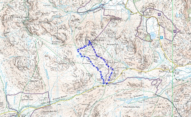

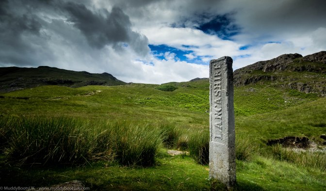
The chosen route was starting at The Three Shires Stone on Wrynose Pass, as this had an 800ft advantage over starting from Oxendale in Great Langdale. As we arrived there was plenty of roadside parking available for us, and I reversed into a nice spot parallel to a Land Rover Freelander. We climbed out of the car and proceeded to change our footwear. We hoisted our rucksacks onto our backs and then set off in a northerly direction.
The routes to the summit of Pike of Blisco are limited if you want to stick to the OS public footpath ways, and so we headed ‘off piste’ over Low Teighton How and towards Green Crag and then on toward Black Crag.
The view down to Little Langdale from Green Crag was wonderful and a dappled sunny day was manifesting itself in the valley below us.
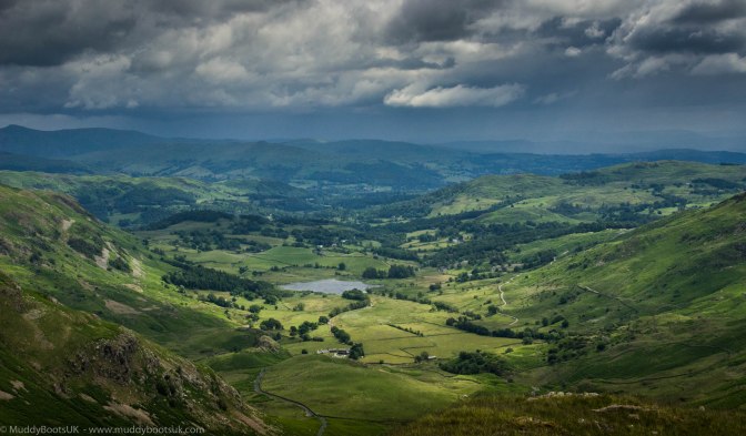
The going was hard as there was no path at all, and we started to follow sheep tracks which headed in the general direction of the summit to make the walking a bit easier. The ground was quite boggy in places so we tried to stay quite close to the various rocky outcrops which littered this high place and there were many tussocks of rough grass. We climbed up and over Green Crag and made a meandering path toward Black Crag whilst taking in the wide and expansive views all around us.
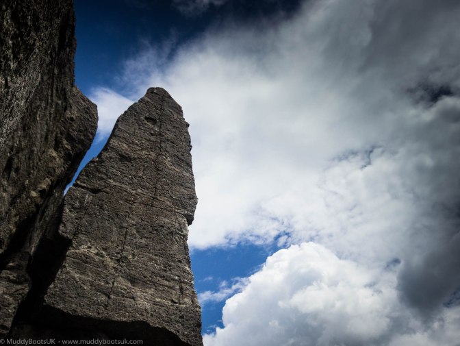
I didn’t know it, but the reason behind Steve heading towards Black Crag was so he could see ‘The Needle’. This is noted in Wainwrights’ fourth Pictorial Guide book about the Southern Fells, and he had obviously researched this prior to choosing this route as it is a bit off the beaten track. It is like a miniature Napes Needle on the flanks of Great Gable.
Wainwright notes that he could find no reference to this being climbed when he wrote the pictorial guide in 1960. How things have moved on! Here is a recent clip of it being conquered.
After spending some time mooching around The Needle, we pressed onward, and upwards. The route was quite steady from here, and there was an obvious path to be taken, well at least more obvious than the sheep tracks which litter the place. As we approached the summit of Pike o’ Blisco, the ground surrounding the top was a maze of rocky outcrops and a circuitous route was taken to actually get to the summit cairn itself.
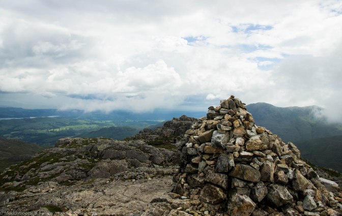
The summit had a number of grassy areas on which to sit and to take in the view. It wasn’t busy like Scafell, but there were three or four others up there taking in the views and munching on their lunch.
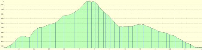
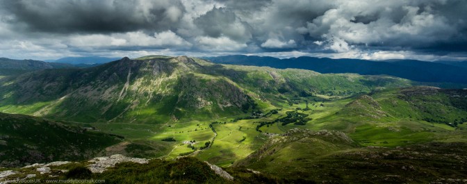
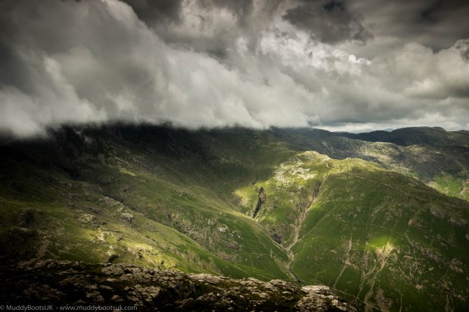
Steve and myself sat on the northern slope overlooking Great Langdale, whilst we consumed the sandwiches he had very kindly provided. The views were very extensive and uninterrupted except for the view up to the North West. This was looking towards Bowfell, Crinkle Crags and beyond to the Scafell range. The clag was down, and it was all shrouded in mist. In fact it looked as through it was a magnet for holding the cloud and mist and thus allowing the rest of the lakes to have clear views. As we sat having our lunch, lone wisps of clouds passed by in front of us which were floating over from Crinkle Crags, and larger amounts of mist tried grasping out towards us, but never enveloping the summit enough to cause concern.
Whilst we were lingering on the summit a rag-tag group of walkers appeared in shorts, trainers and vest type tops and T-shirts. It was a group of young lads, around the very early twenties age group who were over from Newcastle. The Geordie reputation for wearing only a T-shirt in all weathers was ably demonstrated here, as everybody else on the summit had a fleece and shell jacket on – well, I had just just a fleece (..and trousers of course!) but it wasn’t warm enough for just a T-shirt. I got chatting and asked them where they were off, and they pointed over to Pavey Ark and Stickle Tarn. They asked how long it would take, and I estimated about 6 hours. They were going to go along Crinkle Crags, along over Bowfell and Rossett Pike to cross over Stake Pass and thus over to Pavey Ark. I asked them where their map was and they confirmed they didn’t have one, nor a compass. They then set off heading for the the thick clouds shrouding Crinkle Crags – Mon Dieu! No wonder we need Mountain Rescue Teams.
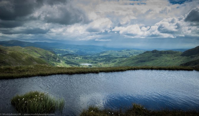
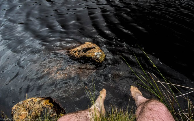
We finished our sandwiches and made our way down. The route Steve had chosen took the path almost directly down to Red Tarn. The temperature had risen considerably now were were off the tops, and we took the opportunity to remove boots and socks and dangle our feet into the cooling waters of the Tarn. I half expected my feet to hiss as they touched the glittering water. It was wonderful to lie back on the soft grass and have the Tarn soothe and cool me plates of meat, whilst I closed my eyes. I could have stayed there for a couple of hours and dozed in the warm sunshine.
After drying my feet and pulling on my socks and boots, we were off again along a well made path leading below Long Scar and heading the direction of Wrynose Pass. We made rapid progress along here and made a steady descent back down to the Three Shire Stone at Wrynose. We passed it by, and went back to the car where we gratefully took off our rucksacks and boots, put them in the back of the car, changed our footwear and set off to Ambleside in search of that Alfred Wainwright favourite, fish and chips.
Post Script
Whilst sat in a back street fish and chip shop in Ambleside we heard a number of familiar voices. It was the group of Geordie lads I was talking to on the summit of Pike o’ Blisco – the MRT had not been called out for them afterall. They had gone along Crinkle Crags by following somebody else who knew the route, and got to Three Tarns where they threw the towel in. They turned right down The Band and walked back to their cars and then driven to Ambleside for fish and chips like ourselves. I was pleased to see that they had come to no harm.
